


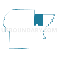
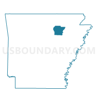
Dota Voting District, Independence County, Arkansas
About
Outline

Summary
| Unique Area Identifier | 526688 |
| Name | Dota Voting District |
| County | Independence County |
| State | Arkansas |
| Area (square miles) | 47.71 |
| Land Area (square miles) | 47.71 |
| Water Area (square miles) | 0.00 |
| % of Land Area | 100.00 |
| % of Water Area | 0.00 |
| Latitude of the Internal Point | 35.83442940 |
| Longtitude of the Internal Point | -91.41200950 |
Maps

Graphs
Select a template below for downloading or customizing gragh for Dota Voting District, Independence County, Arkansas


Neighbors
Neighoring Voting District (by Name) Neighboring Voting District on the Map
- Barren Voting District, Independence County, AR
- Big Bottom-Wycough-Logan Voting District, Independence County, AR
- Blackriver Marshall Voting District, Independence County, AR
- Gainsboro Voting District, Independence County, AR
- REED'S CREEK Voting District, Lawrence County, AR
- Scott Voting District, Sharp County, AR
- White River Voting District, Independence County, AR
Top 10 Neighboring County Subdivision (by Population) Neighboring County Subdivision on the Map
- Big Bottom-Wycough-Logan township, Independence County, AR (1,927)
- Barren township, Independence County, AR (1,483)
- Gainsboro township, Independence County, AR (1,128)
- Dota township, Independence County, AR (1,092)
- Reeds Creek township, Lawrence County, AR (958)
- Scott township, Sharp County, AR (434)
- Black River-Marshell township, Independence County, AR (341)
Top 10 Neighboring Unified School District (by Population) Neighboring Unified School District on the Map
- Batesville School District, AR (19,573)
- Cave City School District, AR (8,385)
- Cedar Ridge School District, AR (5,465)
- Hillcrest School District, AR (3,680)
Top 10 Neighboring State Legislative District Lower Chamber (by Population) Neighboring State Legislative District Lower Chamber on the Map
- State House District 82, AR (28,911)
- State House District 72, AR (28,138)
- State House District 73, AR (26,277)
Top 10 Neighboring State Legislative District Upper Chamber (by Population) Neighboring State Legislative District Upper Chamber on the Map
- State Senate District 12, AR (83,956)
- State Senate District 11, AR (80,865)
- State Senate District 10, AR (80,214)
Top 10 Neighboring 111th Congressional District (by Population) Neighboring 111th Congressional District on the Map
Top 10 Neighboring Census Tract (by Population) Neighboring Census Tract on the Map
- Census Tract 4901, Independence County, AR (6,263)
- Census Tract 4704, Sharp County, AR (5,999)
- Census Tract 4904, Independence County, AR (4,283)
- Census Tract 4703, Lawrence County, AR (1,990)
Top 10 Neighboring 5-Digit ZIP Code Tabulation Area (by Population) Neighboring 5-Digit ZIP Code Tabulation Area on the Map
- 72501, AR (25,099)
- 72521, AR (4,814)
- 72562, AR (2,238)
- 72579, AR (1,287)
- 72469, AR (1,124)
- 72522, AR (405)
- 72524, AR (376)
- 72572, AR (228)